


Bradshaw Voting District, Yakima County, Washington
About
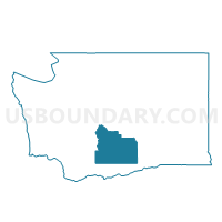
Outline

Summary
| Unique Area Identifier | 690166 |
| Name | Bradshaw Voting District |
| County | Yakima County |
| State | Washington |
| Area (square miles) | 47.90 |
| Land Area (square miles) | 47.90 |
| Water Area (square miles) | 0.00 |
| % of Land Area | 100.00 |
| % of Water Area | 0.00 |
| Latitude of the Internal Point | 46.48548010 |
| Longtitude of the Internal Point | -120.53647840 |
Maps


Graphs
Select a template below for downloading or customizing gragh for Bradshaw Voting District, Yakima County, Washington


Neighbors
Neighoring Voting District (by Name) Neighboring Voting District on the Map
- E Wapato Voting District, Yakima County, WA
- Fullbright Voting District, Yakima County, WA
- Harrah Rural Voting District, Yakima County, WA
- Parker Heights Voting District, Yakima County, WA
- S Ahtanum Voting District, Yakima County, WA
- S Hills Voting District, Yakima County, WA
- Wapato Voting District, Yakima County, WA
- White Swan Voting District, Yakima County, WA
Top 10 Neighboring County Subdivision (by Population) Neighboring County Subdivision on the Map
- Toppenish-Wapato CCD, Yakima County, WA (27,150)
- Northeast Yakima CCD, Yakima County, WA (9,106)
- South Yakima CCD, Yakima County, WA (3,682)
Top 10 Neighboring Place (by Population) Neighboring Place on the Map
Top 10 Neighboring Unified School District (by Population) Neighboring Unified School District on the Map
- West Valley School District, WA (28,648)
- Wapato School District, WA (13,777)
- Mount Adams School District, WA (4,380)
Top 10 Neighboring State Legislative District Lower Chamber (by Population) Neighboring State Legislative District Lower Chamber on the Map
Top 10 Neighboring State Legislative District Upper Chamber (by Population) Neighboring State Legislative District Upper Chamber on the Map
Top 10 Neighboring 111th Congressional District (by Population) Neighboring 111th Congressional District on the Map
Top 10 Neighboring Census Tract (by Population) Neighboring Census Tract on the Map
- Census Tract 9400.04, Yakima County, WA (6,777)
- Census Tract 9400.01, Yakima County, WA (6,409)
- Census Tract 17.02, Yakima County, WA (6,023)
- Census Tract 9400.02, Yakima County, WA (4,430)
- Census Tract 9400.03, Yakima County, WA (3,682)